
1965 Map of Craig
USGS Topo · Published 1965About this map
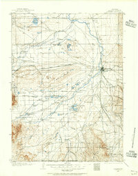
Continental Divide winds through the heart of Northwest Colorado in this mid-1960s survey, marking the jagged boundary between the Yampa River and White River basins and the headwaters of the North Platte River. The landscape is defined by vast tracts of the Routt National Forest and Arapaho National Forest, where high alpine lakes like Trappers Lake and Grand Lake sit among the Park Range and Front Range. Industrial activity centers on Coal mining near the Yampa River, while the Denver and Rio Grande Western railroad tracks the southern river corridors. The map records a crucial era of water management, showing the Wolford Mountain Reservoir and the interconnected waters of Lake Granby and Shadow Mountain Lake before later developments altered the high-country hydrology.
Find a feature on this map
81 named features on this map. Tap any name to fly to it.
Don’t see what you’re looking for? This feature index may not catch every label — zoom into the map to look around manually.
Map Details
Editions of this 1965 Craig Map
This is the sole edition of this map. No revisions or reprints were ever made.
Other maps of this area

1895 · Laramie
USGS Topo · 1:125,000

1902 · Laramie
USGS Topo · 1:125,000

1905 · Laramie
USGS Topo · 1:125,000

1906 · Medicine Bow
USGS Topo · 1:125,000
1906 · Laramie
USGS Topo · 1:125,000

1906 · Grand Hogback
USGS Topo · 1:125,000

1907 · White River
USGS Topo · 1:125,000
1908 · Laramie
USGS Topo · 1:125,000

1908 · Medicine Bow
USGS Topo · 1:125,000

1910 · Danforth Hills
USGS Topo · 1:125,000