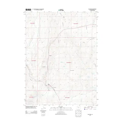
2013 Map of Oak Creek
USGS Topo · Published 2013About this map
Oak Creek serves as the primary hub for this portion of Routt County, situated along the winding path of Co RD 131. The settlement pattern reflects the area's agricultural and resource-based history, with smaller locations like Haybro and Keystone positioned north of the main town. The landscape is defined by its complex water management systems, including the Oak Dale Ditch, Highline Ditch, and Homestead Ditch, which redirect water across the varied terrain toward larger bodies like the Stagecoach Reservoir and Henderson Reservoir.
Find a feature on this map
50 named features on this map. Tap any name to fly to it.
Don’t see what you’re looking for? This feature index may not catch every label — zoom into the map to look around manually.
Map Details
Editions of this 2013 Oak Creek Map
This is the sole edition of this map. No revisions or reprints were ever made.
Other maps of this area

1924 · Mt. Harris
USGS Topo · 1:48,000

1926 · Mount Harris
USGS Topo · 1:62,500

1954 · Craig
USGS Topo · 1:250,000

1957 · Craig
USGS Topo · 1:250,000

1958 · Craig
USGS Topo · 1:250,000

1960 · Craig
USGS Topo · 1:250,000

1962 · Craig
USGS Topo · 1:250,000

1964 · Craig
USGS Topo · 1:250,000

1965 · Craig
USGS Topo · 1:250,000
1966 · Sand Point
USGS Topo · 1:24,000