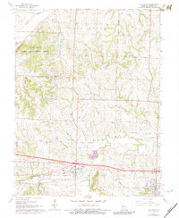
1965 Map of Oak Grove
USGS Topo · Published 1984About this map
The Lake City Army Ammunition Plant dominates the northwestern corner of this landscape, marking a massive industrial and military footprint just north of the Pacific railroad line. Further south, the growing corridor between Grain Valley and Oak Grove is visible, centered around the Illinois Central Gulf railroad and the burgeoning infrastructure of the East Kansas City Airport. This mid-century survey reveals a transition from a primary agricultural economy to one shaped by suburban expansion and military utility.
Find a feature on this map
37 named features on this map. Tap any name to fly to it.
Don’t see what you’re looking for? This feature index may not catch every label — zoom into the map to look around manually.
Map Details
Editions of this 1965 Oak Grove Map
3 editions found
Other maps of this area

1887 · Harrisonville
USGS Topo · 1:125,000

1892 · Harrisonville
USGS Topo · 1:125,000

1894 · Harrisonville
USGS Topo · 1:125,000

1894 · Independence
USGS Topo · 1:125,000

1933 · Blue Springs
USGS Topo · 1:24,000

1934 · Oak Grove
USGS Topo · 1:24,000

1934 · Woods Chapel
USGS Topo · 1:24,000

1935 · Buckner
USGS Topo · 1:24,000

1935 · Missouri City
USGS Topo · 1:24,000

1935 · Tarsney
USGS Topo · 1:24,000