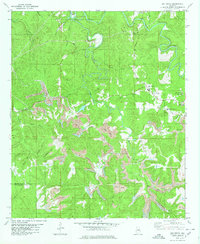
1980 Map of Oak Grove
USGS Topo · Published 1980About this map
Valley Creek meanders deeply through this portion of Jefferson and Tuscaloosa Counties, defining a landscape shaped by industrial extraction and rural settlement. During the late 1970s, the region around Oak Grove was characterized by extensive surface mining operations, with numerous Strip Mine sites and a Tailings Pond visible across the terrain. These heavy industrial footprints contrast with established community centers like Toadvine and Betty Hill, where local life centered around institutions such as Mud Creek Ch and Big Creek Ch.
Find a feature on this map
48 named features on this map. Tap any name to fly to it.
Don’t see what you’re looking for? This feature index may not catch every label — zoom into the map to look around manually.
Map Details
Editions of this 1980 Oak Grove Map
2 editions found
Other maps of this area

1893 · Jasper
USGS Topo · 1:125,000

1899 · Brookwood
USGS Topo · 1:125,000

1927 · Adger
USGS Topo · 1:48,000

1929 · Searles
USGS Topo · 1:48,000

1932 · Yolande
USGS Topo · 1:62,500

1934 · Searles
USGS Topo · 1:62,500

1935 · Port Birmingham
USGS Topo · 1:48,000

1935 · Yolande
USGS Topo · 1:62,500

1938 · Port Birmingham
USGS Topo · 1:62,500

1949 · Tutwiler School
USGS Topo · 1:24,000