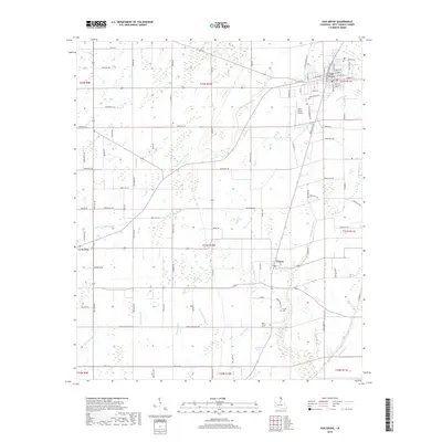
2018 Map of Oak Grove
USGS Topo · Published 2018About this map
The town of Oak Grove serves as the focal point of this northeastern Louisiana landscape, positioned where the terrain transitions into a complex network of waterways. The settlement pattern is defined by a grid of rural roads and parish routes that navigate around numerous bayous, including Little Colewa Bayou, Big Henson Bayou, and Alligator Bayou. These watercourses, characteristic of the Mississippi Delta region, dictate the placement of farms and homesteads. Further south, the community of Forest appears as a secondary hub, flanked by both the Forest Cem and New Forest Cem. This 2018 survey also highlights the local transportation infrastructure, from the Kelly-Dumas Airport to family-named routes like Wiley Farms Rd and Savage Rd, offering a detailed view of West Carroll Parish's contemporary rural geography and agricultural layout.
Find a feature on this map
103 named features on this map. Tap any name to fly to it.
Don’t see what you’re looking for? This feature index may not catch every label — zoom into the map to look around manually.
Map Details
Editions of this 2018 Oak Grove Map
This is the sole edition of this map. No revisions or reprints were ever made.
Other maps of this area

1909 · Baxter Bayou
USGS Topo · 1:24,000

1909 · Ashton Bridge
USGS Topo · 1:24,000

1911 · Baxter Bayou
USGS Topo · 1:24,000

1912 · Ashton Bridge
USGS Topo · 1:31,680

1914 · Baxter Bayou
USGS Topo · 1:31,680

1935 · Hurricane
USGS Topo · 1:62,500

1935 · Oak Grove
USGS Topo · 1:62,500

1935 · Bonita
USGS Topo · 1:62,500

1955 · Jackson
USGS Topo · 1:250,000

1958 · Oak Grove
USGS Topo · 1:62,500