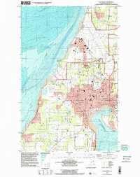
1998 Map of Oak Harbor
USGS Topo · Published 2002About this map
Whidbey Island Naval Air Station dominates the northern landscape of Whidbey Island in this late 20th-century survey, its expansive airfield and support structures bordering Clover Valley and Monkey Hill. The city of Oak Harbor is shown in detail, revealing its transition from a waterfront settlement into a regional hub with numerous schools like North Whidbey Jr HS and Olympic View School.
Find a feature on this map
58 named features on this map. Tap any name to fly to it.
Don’t see what you’re looking for? This feature index may not catch every label — zoom into the map to look around manually.
Map Details
Editions of this 1998 Oak Harbor Map
This is the sole edition of this map. No revisions or reprints were ever made.
Other maps of this area

1939 · Port Townsend
USGS Topo · 1:62,500

1939 · Coupeville
USGS Topo · 1:62,500

1943 · Richardson
USGS Topo · 1:62,500

1943 · Deception Pass
USGS Topo · 1:62,500

1951 · Deception Pass
USGS Topo · 1:62,500

1953 · Coupeville
USGS Topo · 1:24,000

1953 · Camano
USGS Topo · 1:24,000

1953 · Port Townsend North
USGS Topo · 1:24,000

1957 · Richardson
USGS Topo · 1:62,500

1957 · Victoria
USGS Topo · 1:250,000