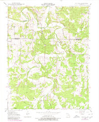
1948 Map of Oak Hill
USGS Topo · Published 1980About this map
Family cemeteries dot the rolling landscape across the Gasconade and Crawford County line, reflecting a deeply rooted rural settlement pattern. The small community of Oak Hill serves as a central point in an area defined by winding watercourses like the Bourbeuse River and Brush Creek. This mid-century survey reveals a network of country roads, such as Prairie Road, that connect isolated farmsteads to local landmarks including the Blue Spring Sch. The high density of named family burial grounds, from Ruwwe Cem in the north to Mc Williams Cem in the south, provides an invaluable resource for genealogists tracing early Missouri settlers. Notable topography includes the distinct valley of Pleasant Valley Creek and the drainage patterns of Souder Creek and Threemile Creek, which influenced the placement of original homesteads and schoolhouses throughout the township.
Find a feature on this map
31 named features on this map. Tap any name to fly to it.
Don’t see what you’re looking for? This feature index may not catch every label — zoom into the map to look around manually.
Map Details
Editions of this 1948 Oak Hill Map
3 editions found

Other maps of this area

1903 · Sullivan
USGS Topo · 1:125,000

1934 · Bland
USGS Topo · 1:62,500

1934 · Redbird
USGS Topo · 1:62,500

1935 · Gerald
USGS Topo · 1:48,000

1937 · Bland
USGS Topo · 1:62,500

1938 · Redbird
USGS Topo · 1:62,500

1941 · Gerald
USGS Topo · 1:62,500

1944 · Gerald
USGS Topo · 1:62,500

1948 · Cuba
USGS Topo · 1:24,000

1948 · Leasburg
USGS Topo · 1:24,000