
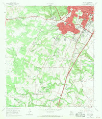
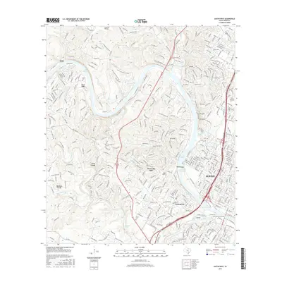
1966 Map of Oak Hill
USGS Topo · Published 1986About this map
The expanding southern edge of Austin meets the rolling hills of Central Texas in this mid-1960s survey, updated with 1970s urban growth patterns. The landscape is defined by the rugged drainage of Barton Creek and Williamson Creek, where residential sprawl begins to surround older established communities like Sunset Valley and Kinecheonville. Major infrastructure projects like Ben White Blvd and South Congress signal the post-war transition from a rural ranching economy to a suburban center.
Find a feature on this map
69 named features on this map. Tap any name to fly to it.
Don’t see what you’re looking for? This feature index may not catch every label — zoom into the map to look around manually.
Map Details
Editions of this 1966 Oak Hill Map
2 editions found
Historical Maps of Austin Through Time
107 maps found

1930 Austin-2
Travis County, TX

1930 Blanco-1
Travis County, TX

1932 Mt. Bonnell
Travis County, TX

1954 Austin East
Travis County, TX

1954 Austin West
Travis County, TX

1955 Montopolis
Travis County, TX

1955 Montopolis
Travis County, TX

1955 Oak Hill
Travis County, TX

1959 Lake Travis
Travis County, TX

1962 Nameless
Travis County, TX

1966 Austin East
Travis County, TX

1966 Austin West
Travis County, TX

1966 Montopolis
Travis County, TX
1966 Oak Hill
Travis County, TX

1966 Travis Peak
Travis County, TX

1967 Pace Bend
Travis County, TX

1967 Shingle Hills
Travis County, TX

1968 Jollyville
Travis County, TX

1968 Mansfield Dam
Travis County, TX

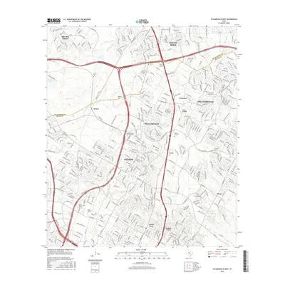
1968 Pflugerville East
Travis County, TX

1968 Pflugerville West
Travis County, TX

1968 Signal Hill
Travis County, TX

1973 Montopolis
Travis County, TX

1982 Elgin West
Travis County, TX

1986 Mansfield Dam
Travis County, TX

1986 Nameless
Travis County, TX

1986 Pace Bend
Travis County, TX

1986 Shingle Hills
Travis County, TX

1986 Signal Hill
Travis County, TX

1986 Travis Peak
Travis County, TX

1987 Jollyville
Travis County, TX

1987 Pflugerville East
Travis County, TX

1987 Pflugerville West
Travis County, TX

1988 Austin East
Travis County, TX

1988 Austin West
Travis County, TX

1988 Montopolis
Travis County, TX

1988 Oak Hill
Travis County, TX

2010 Austin East
Travis County, TX
2010 Austin West
Travis County, TX

2010 Elgin West
Travis County, TX

2010 Jollyville
Travis County, TX

2010 Mansfield Dam
Travis County, TX

2010 Montopolis
Travis County, TX

2010 Nameless
Travis County, TX

2010 Oak Hill
Travis County, TX

2010 Pace Bend
Travis County, TX

2010 Pflugerville East
Travis County, TX

2010 Pflugerville West
Travis County, TX

2010 Shingle Hills
Travis County, TX

2010 Signal Hill
Travis County, TX

2010 Travis Peak
Travis County, TX

2012 Elgin West
Travis County, TX

2012 Pace Bend
Travis County, TX

2012 Shingle Hills
Travis County, TX

2012 Travis Peak
Travis County, TX
2013 Austin East
Travis County, TX
2013 Austin West
Travis County, TX

2013 Jollyville
Travis County, TX

2013 Mansfield Dam
Travis County, TX

2013 Montopolis
Travis County, TX

2013 Nameless
Travis County, TX

2013 Oak Hill
Travis County, TX

2013 Pflugerville East
Travis County, TX

2013 Pflugerville West
Travis County, TX

2013 Signal Hill
Travis County, TX

2016 Austin East
Travis County, TX
2016 Austin West
Travis County, TX

2016 Elgin West
Travis County, TX

2016 Jollyville
Travis County, TX

2016 Mansfield Dam
Travis County, TX

2016 Montopolis
Travis County, TX

2016 Nameless
Travis County, TX

2016 Oak Hill
Travis County, TX

2016 Pace Bend
Travis County, TX

2016 Pflugerville East
Travis County, TX
2016 Pflugerville West
Travis County, TX

2016 Shingle Hills
Travis County, TX

2016 Signal Hill
Travis County, TX

2016 Travis Peak
Travis County, TX

2019 Austin East
Travis County, TX

2019 Austin West
Travis County, TX

2019 Elgin West
Travis County, TX

2019 Jollyville
Travis County, TX

2019 Mansfield Dam
Travis County, TX

2019 Montopolis
Travis County, TX

2019 Nameless
Travis County, TX

2019 Oak Hill
Travis County, TX

2019 Pace Bend
Travis County, TX

2019 Pflugerville East
Travis County, TX

2019 Pflugerville West
Travis County, TX

2019 Shingle Hills
Travis County, TX
2019 Signal Hill
Travis County, TX
2019 Travis Peak
Travis County, TX

2022 Austin East
Travis County, TX

2022 Austin West
Travis County, TX

2022 Elgin West
Travis County, TX

2022 Jollyville
Travis County, TX

2022 Mansfield Dam
Travis County, TX

2022 Montopolis
Travis County, TX

2022 Oak Hill
Travis County, TX

2022 Pace Bend
Travis County, TX

2022 Pflugerville East
Travis County, TX

2022 Pflugerville West
Travis County, TX

2022 Shingle Hills
Travis County, TX

2022 Signal Hill
Travis County, TX

2022 Travis Peak
Travis County, TX

2023 Nameless
Travis County, TX