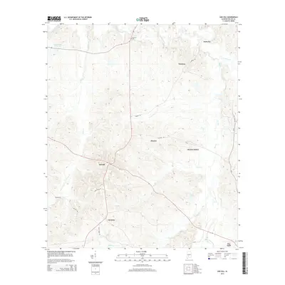
2014 Map of Oak Hill
USGS Topo · Published 2014About this map
Oak Hill and Pine Apple anchor this Wilcox County landscape, where the terrain is defined by the winding paths of Pine Barren Cr and Prairie Cr. The map shows a rural settlement pattern that follows the ridges and creek valleys, connecting historical points such as Caledonia and Allenton. The transition from the higher ground near Oak Hill down toward the drainage basins of Callie Cr and Bear Cr highlights the region's agricultural and timber-driven geography. Local family history is rooted in sites like McConico Cem, while the inclusion of Allenton Station reflects the historical importance of transit corridors through this part of Alabama. Other notable water features include Lambert Bama Ranch Lake and Hale Lake, which dot the landscape alongside a network of local routes like Hamburg Rd and Wagon Wheel Rd.
Find a feature on this map
25 named features on this map. Tap any name to fly to it.
Don’t see what you’re looking for? This feature index may not catch every label — zoom into the map to look around manually.
Map Details
Editions of this 2014 Oak Hill Map
This is the sole edition of this map. No revisions or reprints were ever made.
Other maps of this area

1953 · Montgomery
USGS Topo · 1:250,000

1953 · Andalusia
USGS Topo · 1:250,000

1956 · Montgomery
USGS Topo · 1:250,000

1957 · Montgomery
USGS Topo · 1:250,000

1957 · Andalusia
USGS Topo · 1:250,000

1957 · Carlowville
USGS Topo · 1:62,500

1957 · Braggs
USGS Topo · 1:62,500
1981 · Rosebud
USGS Topo · 1:24,000
1981 · Oak Hill
USGS Topo · 1:24,000

1981 · Pine Apple North
USGS Topo · 1:24,000