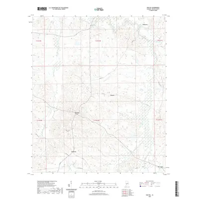
2020 Map of Oak Hill
USGS Topo · Published 2020About this map
Oak Hill and Pine Apple anchor this segment of Wilcox County, where the landscape is defined by the complex drainage of the Pine Barren Creek watershed. This recent 2020 survey illustrates the rural continuity of the region, documenting small settlements like Caledonia, Allenton, and McBrydes that have long served as local centers. The terrain is marked by numerous watercourses including Prairie Cr, Callie Cr, and Bear Creek, which carve through the topography alongside a network of local routes such as Sheffield Rd and Hamburg Rd. Genealogists may find particular value in the documentation of the McConico Cem located north of Oak Hill. The map provides a contemporary view of these traditional Alabama communities, showing how established crossroads and family landmarks remain central to the local geography.
Find a feature on this map
28 named features on this map. Tap any name to fly to it.
Don’t see what you’re looking for? This feature index may not catch every label — zoom into the map to look around manually.
Map Details
Editions of this 2020 Oak Hill Map
This is the sole edition of this map. No revisions or reprints were ever made.
Other maps of this area

1953 · Montgomery
USGS Topo · 1:250,000

1953 · Andalusia
USGS Topo · 1:250,000

1956 · Montgomery
USGS Topo · 1:250,000

1957 · Montgomery
USGS Topo · 1:250,000

1957 · Andalusia
USGS Topo · 1:250,000

1957 · Carlowville
USGS Topo · 1:62,500

1957 · Braggs
USGS Topo · 1:62,500
1981 · Rosebud
USGS Topo · 1:24,000
1981 · Oak Hill
USGS Topo · 1:24,000

1981 · Pine Apple North
USGS Topo · 1:24,000