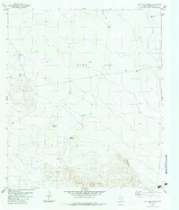
1983 Map of Oak Hills North
USGS Topo · Published 1983About this map
Ryan Flat dominates the northern half of this West Texas landscape, a broad expanse defined by essential water management features necessary for ranching. In the early 1980s, the area relied on a network of named catchment basins and wells, including Horseshoe Tank, Brite Tank, and the Rattlesnake Windmill. The presence of the Buena Vista Ranch and a remote Landing Strip near the eastern edge suggests the logistical realities of managing such large, arid landholdings.
Find a feature on this map
16 named features on this map. Tap any name to fly to it.
Don’t see what you’re looking for? This feature index may not catch every label — zoom into the map to look around manually.
Map Details
Editions of this 1983 Oak Hills North Map
This is the sole edition of this map. No revisions or reprints were ever made.
Other maps of this area

1895 · Marfa
USGS Topo · 1:125,000

1959 · Marfa
USGS Topo · 1:250,000

1965 · Marfa
USGS Topo · 1:250,000
1983 · Ryan
USGS Topo · 1:24,000
1983 · Aragon
USGS Topo · 1:24,000
1983 · Cuesta Del Burro NW
USGS Topo · 1:24,000
1983 · Burro Draw
USGS Topo · 1:24,000
1983 · Deer Peak
USGS Topo · 1:24,000
1983 · Oak Creek
USGS Topo · 1:24,000
1983 · Oak Hills South
USGS Topo · 1:24,000