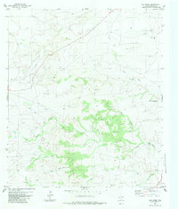
1983 Map of Oak Creek
USGS Topo · Published 1983About this map
The arid landscape of Presidio County is defined here by a network of ephemeral water sources and ranching infrastructure recorded during the mid-1970s. Arising from drainage systems like Long Draw and Shannon Draw, the topography is carved by seasonal watercourses including Oak Creek, Saucita Creek, and Julia Creek. These features illustrate the vital importance of water management in West Texas, where isolated landmarks like the San Esteban Dam Waterhole and Hackberry Tank served as critical points for livestock and land use. Named family landmarks such as Walker Well, Goadley Windmill, and Brice Windmill provide specific points of interest for local historians and genealogists tracing ranching heritage in this high-elevation terrain. This survey reflects the geography prior to modern developments, preserving the locations of remote wells and tanks that once supported the local economy.
Find a feature on this map
12 named features on this map. Tap any name to fly to it.
Don’t see what you’re looking for? This feature index may not catch every label — zoom into the map to look around manually.
Map Details
Editions of this 1983 Oak Creek Map
This is the sole edition of this map. No revisions or reprints were ever made.
Other maps of this area

1895 · Marfa
USGS Topo · 1:125,000

1959 · Marfa
USGS Topo · 1:250,000

1965 · Marfa
USGS Topo · 1:250,000
1983 · San Esteban Lake
USGS Topo · 1:24,000
1983 · Marfa
USGS Topo · 1:24,000
1983 · Aragon
USGS Topo · 1:24,000

1983 · Cuesta Del Burro East
USGS Topo · 1:24,000
1983 · Frenchman Hills
USGS Topo · 1:24,000
1983 · San Esteban Lake SW
USGS Topo · 1:24,000
1983 · Oak Hills North
USGS Topo · 1:24,000