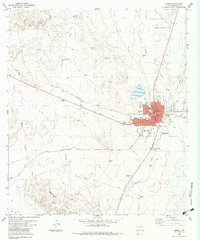
1983 Map of Marfa
USGS Topo · Published 1983About this map
The high desert landscape of Marfa is defined by a distinct urban grid set against the vast drainage systems of the Trans-Pecos. In the early 1980s, the town remains centered on its historic Courthouse and the Southern Pacific railroad line, which bisects the community. Local history is anchored by the St Marys Sch, High Sch, and multiple cemeteries including Holmes Cem. The surrounding terrain is marked by intermittent water features like Alamito Creek, Fourmile Draw, and the curiously named Porter Waterhole to the north. Evidence of the region’s ranching and utility infrastructure is everywhere, from the Cardwell Windmill to the Marfa Municipal Airport. Cultural and recreational life is visible through landmarks such as the Drive-in Theater and Coffield Park, reflecting the town's role as a regional hub even as it maintains its remote character near the Rancheria Hills.
Find a feature on this map
39 named features on this map. Tap any name to fly to it.
Don’t see what you’re looking for? This feature index may not catch every label — zoom into the map to look around manually.
Map Details
Editions of this 1983 Marfa Map
This is the sole edition of this map. No revisions or reprints were ever made.
Other maps of this area

1895 · Marfa
USGS Topo · 1:125,000

1895 · Alpine
USGS Topo · 1:125,000

1954 · Fort Stockton
USGS Topo · 1:250,000

1958 · Fort Stockton
USGS Topo · 1:250,000

1959 · Marfa
USGS Topo · 1:250,000

1965 · Marfa
USGS Topo · 1:250,000

1972 · Nopal
USGS Topo · 1:24,000
1972 · Mano Prieto Mountain
USGS Topo · 1:24,000

1973 · Fort Stockton
USGS Topo · 1:250,000
1983 · Tinaja
USGS Topo · 1:24,000