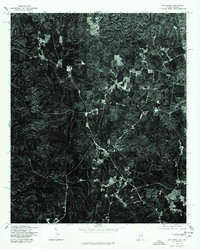
1975 Map of Oak Level
USGS Topo · Published 1977About this map
The borderlands of Alabama and Georgia appear in this orthophotograph produced from aerial photography taken in late 1975. This specialized survey by the U.S. Geological Survey and the Soil Conservation Service offers a unique overhead perspective of the landscape as it appeared in the mid-1970s. The settlement of Piney Woods serves as a central focal point for the road network, which winds through a terrain predominantly shaped by timber and agriculture. The detailed imagery reveals the patchwork of cleared fields and dense woods characteristic of Cleburne County, showing the exact footprint of homesteads and farm roads that may not be recorded on traditional line-drawn maps. This aerial study is particularly valuable for documenting the precise boundary between forested tracts and cultivated land at a time when rural land use was undergoing significant shifts.
Find a feature on this map
1 named feature on this map. Tap any name to fly to it.
Don’t see what you’re looking for? This feature index may not catch every label — zoom into the map to look around manually.
Map Details
Editions of this 1975 Oak Level Map
This is the sole edition of this map. No revisions or reprints were ever made.
Other maps of this area

1889 · Tallapoosa
USGS Topo · 1:125,000

1892 · Tallapoosa
USGS Topo · 1:125,000

1897 · Tallapoosa
USGS Topo · 1:125,000

1900 · Anniston
USGS Topo · 1:125,000

1953 · Atlanta
USGS Topo · 1:250,000

1957 · Atlanta
USGS Topo · 1:250,000

1958 · Atlanta
USGS Topo · 1:250,000

1965 · Tallapoosa South
USGS Topo · 1:24,000

1966 · Tallapoosa North
USGS Topo · 1:24,000
1966 · Benedict
USGS Topo · 1:24,000