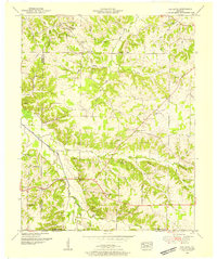
1951 Map of Oak Level
USGS Topo · Published 1955About this map
Oak Level and its surrounding communities sit at a crossroads of Western Kentucky history, where family legacies are marked by dozens of small burial grounds across the landscape. The West Fork Clarks River meanders through the western portion of the quadrangle, defining the lowlands near the Graves Co Marshall Co line. This early 1950s survey shows a rural economy centered on community landmarks like the Oak Level School and Soldier Creek Church. Genealogists will find a high concentration of family-named cemeteries, including the Bondurant Cem, Stanfield Cem, and Gibson Cem, indicating long-standing settlement patterns prior to mid-century modernization. The terrain rises to distinct points such as Waller Hill and Potato Hill, while the southern reaches near Brewers are fed by the network of Soldier Creek and Duncan Creek.
Find a feature on this map
58 named features on this map. Tap any name to fly to it.
Don’t see what you’re looking for? This feature index may not catch every label — zoom into the map to look around manually.
Map Details
Editions of this 1951 Oak Level Map
This is the sole edition of this map. No revisions or reprints were ever made.
Other maps of this area

1936 · Farmington
USGS Topo · 1:24,000

1936 · Oak Level
USGS Topo · 1:24,000

1936 · Elva
USGS Topo · 1:24,000

1936 · Hardin
USGS Topo · 1:24,000

1936 · Symsonia
USGS Topo · 1:24,000

1936 · Benton
USGS Topo · 1:48,000

1936 · Westplains
USGS Topo · 1:24,000

1936 · Dexter
USGS Topo · 1:24,000

1936 · Kirksey
USGS Topo · 1:24,000
1936 · Briensburg
USGS Topo · 1:24,000