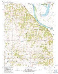
1984 Map of Oak Mills
USGS Topo · Published 1984About this map
The Missouri River corridor north of Leavenworth is defined by the sharp transition from the broad, marshy floodplains of Missouri to the deeply dissected hills of Kansas. Along the eastern bank, the Little Bean Marsh State Natural History Area and Bean Lake sit within a wide river bend, preserving a remnant of the pre-industrial river environment. Directly across the water, the terrain rises into the loess bluffs of the Walnut and Kickapoo townships, where small settlements like Oak Mills and Port Williams are tucked into the drainages of Walnut Creek and Owl Creek.
Find a feature on this map
48 named features on this map. Tap any name to fly to it.
Don’t see what you’re looking for? This feature index may not catch every label — zoom into the map to look around manually.
Map Details
Editions of this 1984 Oak Mills Map
This is the sole edition of this map. No revisions or reprints were ever made.
Other maps of this area

1885 · Atchison
USGS Topo · 1:125,000

1886 · Oskaloosa
USGS Topo · 1:125,000

1888 · Oskaloosa
USGS Topo · 1:125,000

1888 · Atchison
USGS Topo · 1:125,000

1890 · Kansas City
USGS Topo · 1:125,000

1893 · Atchison
USGS Topo · 1:125,000

1894 · Kansas City
USGS Topo · 1:125,000

1894 · Oskaloosa
USGS Topo · 1:125,000

1910 · Leavenworth
USGS Topo · 1:62,500

1926 · Atchison
USGS Topo · 1:62,500