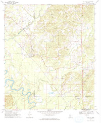
1970 Map of Oak Vale
USGS Topo · Published 1972About this map
The Pearl River serpentines across the southwestern corner of this 1970s landscape, marking a vital natural boundary where Marion Co meets Jefferson Davis Co. The economic life of the region is defined by the intersection of rail and resource, as the Illinois Central railroad cuts a diagonal path through the terrain, connecting the settlements of Oak Vale and Hathorn. Numerous Gravel Pits are scattered throughout the hills, particularly north of the river, suggesting a landscape deeply tied to industrial extraction alongside established rural communities.
Find a feature on this map
28 named features on this map. Tap any name to fly to it.
Don’t see what you’re looking for? This feature index may not catch every label — zoom into the map to look around manually.
Map Details
Editions of this 1970 Oak Vale Map
2 editions found

Other maps of this area

1953 · Hattiesburg
USGS Topo · 1:250,000

1953 · Natchez
USGS Topo · 1:250,000

1956 · Natchez
USGS Topo · 1:250,000

1958 · Hattiesburg
USGS Topo · 1:250,000

1959 · Natchez
USGS Topo · 1:250,000

1970 · Prentiss West
USGS Topo · 1:24,000

1970 · Monticello
USGS Topo · 1:24,000

1970 · Bunker Hill
USGS Topo · 1:24,000

1970 · Darbun
USGS Topo · 1:24,000

1970 · Morgantown
USGS Topo · 1:24,000