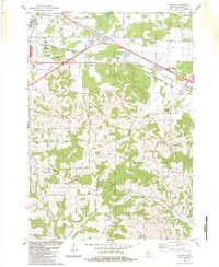
1983 Map of Oakdale
USGS Topo · Published 1984About this map
The Chicago Milwaukee St Paul and Pacific railroad forms a vital corridor through the rolling hills of Monroe County, connecting the bustling hub of Tomah with the smaller settlement of Oakdale. In this 1980s landscape, the industrial footprint is clearly visible through numerous Quarries, Gravel Pits, and a prominent Weigh Station along the highway. The rural character of the region remains rooted in community landmarks such as Sunny Ridge Sch, St Michael Ch, and St Peter Ch. The terrain is marked by distinctive elevations like the Camels Hump and Stone Bluff, while the complex hydrology of the South Fork Lemonweir River and Council Creek systems dictates the local topography. At the edge of Tomah, the V A Hospital Bdy and Veterans Park denote significant public land use, providing a contrast to the surrounding agricultural and industrial zones.
Find a feature on this map
47 named features on this map. Tap any name to fly to it.
Don’t see what you’re looking for? This feature index may not catch every label — zoom into the map to look around manually.
Map Details
Editions of this 1983 Oakdale Map
This is the sole edition of this map. No revisions or reprints were ever made.
Other maps of this area

1916 · Tomah
USGS Topo · 1:62,500

1919 · Kendall
USGS Topo · 1:62,500

1921 · Kendall
USGS Topo · 1:62,500

1947 · Millston
USGS Topo · 1:62,500

1949 · Millston
USGS Topo · 1:62,500

1949 · Tomah
USGS Topo · 1:62,500

1953 · Eau Claire
USGS Topo · 1:250,000

1958 · Eau Claire
USGS Topo · 1:250,000

1958 · Wyeville
USGS Topo · 1:48,000

1958 · La Crosse
USGS Topo · 1:250,000