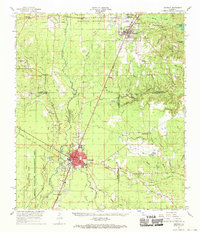
1968 Map of Oakdale
USGS Topo · Published 1970About this map
Oakdale serves as the primary hub of activity in this late 1960s landscape, positioned where the Missouri Pacific Railroad meets the Atchison Topeka and Santa Fe Railroad. The town is well-documented with local landmarks like Oakdale High Sch and the Sacred Heart Ch. To the north, Glenmora and the smaller settlement of McNary sit on the edge of the Kisatchie National Forest, while the southern reaches are dominated by the West Bay State Wildlife Management Area.
Find a feature on this map
73 named features on this map. Tap any name to fly to it.
Don’t see what you’re looking for? This feature index may not catch every label — zoom into the map to look around manually.
Map Details
Editions of this 1968 Oakdale Map
This is the sole edition of this map. No revisions or reprints were ever made.
Other maps of this area

1935 · Beaver
USGS Topo · 1:31,680

1935 · Pawnee
USGS Topo · 1:31,680

1935 · Oakdale
USGS Topo · 1:31,680

1935 · Turkey Creek
USGS Topo · 1:62,500

1935 · Lecompte
USGS Topo · 1:62,500

1942 · Oakdale
USGS Topo · 1:62,500

1943 · Leander
USGS Topo · 1:62,500

1947 · Foley
USGS Topo · 1:31,680

1947 · Steep Gully
USGS Topo · 1:31,680

1947 · Pine Chapel
USGS Topo · 1:31,680