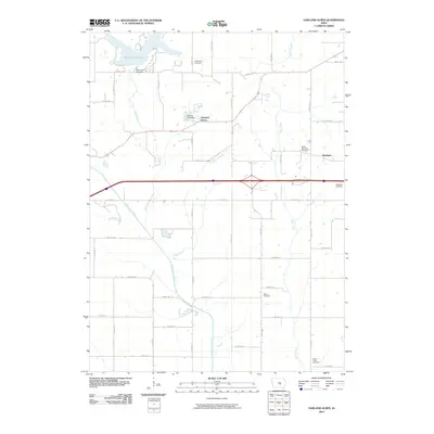
2010 Map of Oakland Acres
USGS Topo · Published 2010About this map
Oakland Acres and its namesake Oakland Acres Dam represent a modern residential landscape integrated with the water resources of Jasper County. This 2010 survey shows the area's transition from the established community of Westfield toward leisure-focused developments around Rock Creek Lake. The map is particularly useful for genealogists, as it documents several small burial grounds scattered across the township, including Bethel Cemetery, West Westfield Cemetery, and the Sugar Creek Cemetery. The local terrain is defined by the drainage of the North Skunk River and its tributaries, such as Turner Creek and Sugar Creek, which carve through the agricultural grid. This network of creeks and the presence of the Rock Creek Lake Dam highlight the area's long-standing relationship between local hydrology and land use.
Find a feature on this map
32 named features on this map. Tap any name to fly to it.
Don’t see what you’re looking for? This feature index may not catch every label — zoom into the map to look around manually.
Map Details
Editions of this 2010 Oakland Acres Map
This is the sole edition of this map. No revisions or reprints were ever made.
Other maps of this area

1954 · Des Moines
USGS Topo · 1:250,000

1956 · Des Moines
USGS Topo · 1:250,000

1957 · Des Moines
USGS Topo · 1:250,000

1969 · Des Moines
USGS Topo · 1:250,000

1979 · Searsboro
USGS Topo · 1:24,000

1979 · Grinnell South
USGS Topo · 1:24,000

1980 · Newburg
USGS Topo · 1:24,000

1980 · Sully
USGS Topo · 1:24,000
1980 · Grinnell North
USGS Topo · 1:24,000
1980 · Alloway Creek
USGS Topo · 1:24,000