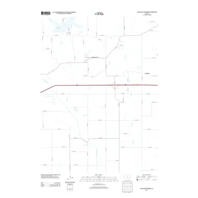
2013 Map of Oakland Acres
USGS Topo · Published 2013About this map
Oakland Acres sits at the heart of this central Iowa landscape, positioned north of the primary transit corridor that cuts across the prairie. The geography is defined by a dendritic network of waterways, including Sugar Cr, Turner Cr, and Rock Cr, all draining toward the N Skunk River in the south. In the northwestern corner, Rock Creek Lake provides a significant water feature, its irregular shoreline contrasting with the rigid grid of rural roads like Co Hwy-T38 and Joy St. This 2013 survey illustrates the intersection of modern interstate travel and established local agricultural life. While the small settlement of Westfield appears to the east, the map is largely a study of rural land divisions and the natural drainage patterns of Jasper County. Notable road names such as Killdeer Ave and Justice Ave define the local grid, marking out the territory between the creeks and the river valley.
Find a feature on this map
62 named features on this map. Tap any name to fly to it.
Don’t see what you’re looking for? This feature index may not catch every label — zoom into the map to look around manually.
Map Details
Editions of this 2013 Oakland Acres Map
This is the sole edition of this map. No revisions or reprints were ever made.
Other maps of this area

1954 · Des Moines
USGS Topo · 1:250,000

1956 · Des Moines
USGS Topo · 1:250,000

1957 · Des Moines
USGS Topo · 1:250,000

1969 · Des Moines
USGS Topo · 1:250,000

1979 · Searsboro
USGS Topo · 1:24,000

1979 · Grinnell South
USGS Topo · 1:24,000

1980 · Newburg
USGS Topo · 1:24,000

1980 · Sully
USGS Topo · 1:24,000
1980 · Grinnell North
USGS Topo · 1:24,000
1980 · Alloway Creek
USGS Topo · 1:24,000