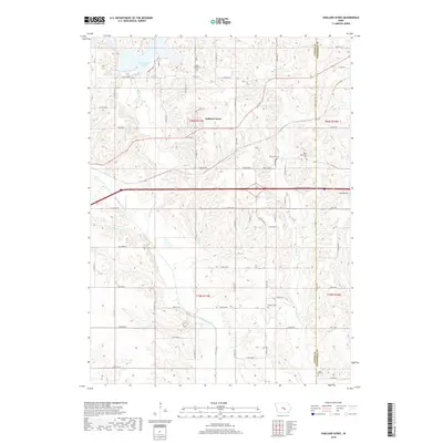
2018 Map of Oakland Acres
USGS Topo · Published 2018About this map
Oakland Acres serves as a modern residential anchor within this rural landscape along the Jasper County and Poweshiek County border. The area is defined by its diverse hydrography, ranging from the prominent Rock Creek Lake in the northwest to the winding course of the North Skunk River cutting through the southern sections. For local historians and genealogists, the map preserves the locations of several burial sites, including the Rock Creek Cem, Westfield Cem, and the uniquely noted Mormon Grave near Sugar Cr. The drainage patterns provided by Rock Cr and Turner Cr underscore the region's agricultural character, where a dense network of country roads such as Co Rd T38 N and N 15th Ave E connects scattered farmsteads across the undulating terrain of central Iowa.
Find a feature on this map
67 named features on this map. Tap any name to fly to it.
Don’t see what you’re looking for? This feature index may not catch every label — zoom into the map to look around manually.
Map Details
Editions of this 2018 Oakland Acres Map
This is the sole edition of this map. No revisions or reprints were ever made.
Other maps of this area

1954 · Des Moines
USGS Topo · 1:250,000

1956 · Des Moines
USGS Topo · 1:250,000

1957 · Des Moines
USGS Topo · 1:250,000

1969 · Des Moines
USGS Topo · 1:250,000

1979 · Searsboro
USGS Topo · 1:24,000

1979 · Grinnell South
USGS Topo · 1:24,000

1980 · Newburg
USGS Topo · 1:24,000

1980 · Sully
USGS Topo · 1:24,000
1980 · Grinnell North
USGS Topo · 1:24,000
1980 · Alloway Creek
USGS Topo · 1:24,000