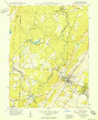
1950 Map of Oakland
USGS Topo · Published 1950About this map
Oakland serves as the hub of this 1948 field-checked landscape, where the Baltimore and Ohio RR follows the Little Youghiogheny River through Mountain Lake Park and Loch Lynn Heights. The map documents a rugged Appalachian frontier defined by the winding Youghiogheny River and the high elevations of Snaggy Mountain, which reaches a peak at the Lookout Tower.
Find a feature on this map
53 named features on this map. Tap any name to fly to it.
Don’t see what you’re looking for? This feature index may not catch every label — zoom into the map to look around manually.
Map Details
Editions of this 1950 Oakland Map
2 editions found
Other maps of this area

1886 · St. George
USGS Topo · 1:125,000

1891 · St. George
USGS Topo · 1:125,000

1895 · Piedmont
USGS Topo · 1:125,000

1899 · Oakland
USGS Topo · 1:62,500

1900 · Accident
USGS Topo · 1:62,500

1900 · Oakland
USGS Topo · 1:62,500

1904 · Bruceton
USGS Topo · 1:62,500

1907 · Kingwood
USGS Topo · 1:62,500

1925 · Kingwood
USGS Topo · 1:62,500

1926 · Bruceton
USGS Topo · 1:62,500