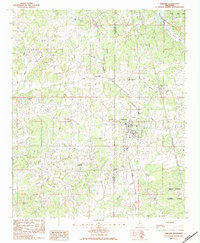
1983 Map of Oakland
USGS Topo · Published 1983About this map
Oakland and Enid center this 1980s landscape at the boundary of Tallahatchie and Yalobusha counties. The eastern edge of the quadrangle is dominated by the waters of Enid Lake and the protected lands of Cossar State Park and Holly Springs National Forest. The Illinois Central Gulf railroad cuts a north-south path through the center of the map, serving as a primary corridor through Tillatoba and the surrounding farmland. The area is notable for its high density of family and community landmarks, including St Paul Ch and St Paul Cem in the north, and numerous rural burial grounds like Womble Cem, Barnes Cem, and Rome Cem. A complex network of waterways, including the North Fork Tillatoba Creek and Kuykendall Creek, threads between the ridges, defining the local topography and the distribution of smaller settlements.
Find a feature on this map
38 named features on this map. Tap any name to fly to it.
Don’t see what you’re looking for? This feature index may not catch every label — zoom into the map to look around manually.
Map Details
Editions of this 1983 Oakland Map
This is the sole edition of this map. No revisions or reprints were ever made.
Other maps of this area

1932 · Philipp
USGS Topo · 1:48,000

1935 · Crowder
USGS Topo · 1:62,500

1935 · Philipp
USGS Topo · 1:62,500

1939 · Crowder
USGS Topo · 1:62,500

1939 · Philipp
USGS Topo · 1:62,500

1948 · Helena
USGS Topo · 1:250,000

1950 · Helena
USGS Topo · 1:250,000

1953 · Greenwood
USGS Topo · 1:250,000

1953 · West Point
USGS Topo · 1:250,000

1954 · Grenada
USGS Topo · 1:62,500