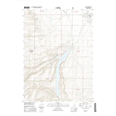
2017 Map of Oakley
USGS Topo · Published 2017About this map
The high desert settlement of Oakley serves as the gateway to the southern Idaho highlands, anchoring an area where managed water systems meeting the foothills of the Sawtooth National Forest. The local economy is visibly centered on the management of Goose Creek, which is captured by the massive Lower Goose Creek Reservoir and diverted through the West Canal to support regional agriculture. The grid of the town site is detailed with named streets from College Ave to Church Ave, while the Oakley Municipal Airport sits just to the east. Moving west and south, the terrain becomes increasingly complex as it rises into the mountains, carved by drainages such as Little Cottonwood Cr and Sawmill Cr. This 2017 survey documents the modern layout of rural infrastructure, including range-access routes like Bostetter Rd and Trapper Creek Rd that lead toward remote water sources like Cowboy Spring.
Find a feature on this map
46 named features on this map. Tap any name to fly to it.
Don’t see what you’re looking for? This feature index may not catch every label — zoom into the map to look around manually.
Map Details
Editions of this 2017 Oakley Map
This is the sole edition of this map. No revisions or reprints were ever made.
Other maps of this area

1954 · Pocatello
USGS Topo · 1:250,000

1955 · Twin Falls
USGS Topo · 1:250,000

1958 · Twin Falls
USGS Topo · 1:250,000

1958 · Pocatello
USGS Topo · 1:250,000

1965 · Buckhorn Canyon
USGS Topo · 1:24,000

1968 · Basin
USGS Topo · 1:24,000
1968 · Blue Hill
USGS Topo · 1:24,000

1968 · Marion SE
USGS Topo · 1:24,000
1968 · Oakley
USGS Topo · 1:24,000

1968 · Lyman Pass
USGS Topo · 1:24,000