
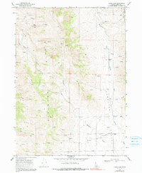
1968 Map of Lyman Pass
USGS Topo · Published 1972About this map
Middle Mountain dominates this high-elevation landscape in Cassia County, where steep slopes transition into the open expanse of Junction Valley to the east. Surveyed in the late 1960s, the map documents a terrain defined by sparse settlement and rugged ranching life. The eastern valley floor shows the Moulton (Site) and the small community of Walters, connected by a network of drainage systems like Junction Creek and Birch Creek.
Find a feature on this map
23 named features on this map. Tap any name to fly to it.
Don’t see what you’re looking for? This feature index may not catch every label — zoom into the map to look around manually.
Map Details
Editions of this 1968 Lyman Pass Map
2 editions found
Other maps of this area

1954 · Pocatello
USGS Topo · 1:250,000

1954 · Brigham City
USGS Topo · 1:250,000

1958 · Pocatello
USGS Topo · 1:250,000

1958 · Brigham City
USGS Topo · 1:250,000

1959 · Cotton Thomas Basin
USGS Topo · 1:62,500

1959 · Yost
USGS Topo · 1:62,500

1962 · Brigham City
USGS Topo · 1:250,000

1968 · Almo
USGS Topo · 1:24,000

1968 · Cache Peak
USGS Topo · 1:24,000

1968 · Basin
USGS Topo · 1:24,000