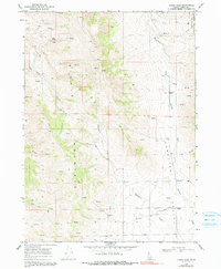
1968 Map of Lyman Pass
USGS Topo · Published 1991About this map
Middle Mountain dominates this landscape in Cassia County, providing a steep backdrop for the historic Applegate Trail that traverses Junction Valley below. The map documents the high-desert terrain during the late 1960s, a place defined by its seasonal springs and rugged drainage systems like Emery Canyon and Cottonwood Creek. The high-altitude boundary of the Sawtooth National Forest extends into the northeastern corner, where the topography rises toward Lyman Pass.
Find a feature on this map
29 named features on this map. Tap any name to fly to it.
Don’t see what you’re looking for? This feature index may not catch every label — zoom into the map to look around manually.
Map Details
Editions of this 1968 Lyman Pass Map
2 editions found

Other maps of this area

1954 · Pocatello
USGS Topo · 1:250,000

1954 · Brigham City
USGS Topo · 1:250,000

1958 · Pocatello
USGS Topo · 1:250,000

1958 · Brigham City
USGS Topo · 1:250,000

1959 · Cotton Thomas Basin
USGS Topo · 1:62,500

1959 · Yost
USGS Topo · 1:62,500

1962 · Brigham City
USGS Topo · 1:250,000

1968 · Almo
USGS Topo · 1:24,000

1968 · Cache Peak
USGS Topo · 1:24,000

1968 · Basin
USGS Topo · 1:24,000