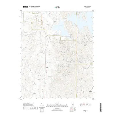
2020 Map of Oakman
USGS Topo · Published 2020About this map
The Coosawattee River and the massive Carters Lake impoundment dominate this north Georgia landscape, where the foothills of the Blue Ridge meet the valley floor. To the west of the high-elevation Blalock Mtn, the Reregulation Reservoir manages the flow downstream from the dam, creating a distinct hydrological environment. The map details a series of small, interconnected settlements such as Oakman, Petersburg, and Ranger, many of which follow the corridor of Old State Hwy 61. Genealogists and local historians will find the Shady Grove Baptist Church Cem near the eastern shore of the lake, along with scattered family-named routes and water features like Evans Lake and Tillman Lake. The terrain is characterized by a dense network of branches and creeks, including Talking Rock Creek and Dry Cr, which carve through the ridges and define the historical settlement patterns of Gordon, Murray, and Gilmer counties.
Find a feature on this map
106 named features on this map. Tap any name to fly to it.
Don’t see what you’re looking for? This feature index may not catch every label — zoom into the map to look around manually.
Map Details
Editions of this 2020 Oakman Map
This is the sole edition of this map. No revisions or reprints were ever made.
Other maps of this area

1886 · Dalton
USGS Topo · 1:125,000

1890 · Cartersville
USGS Topo · 1:125,000

1891 · Cartersville
USGS Topo · 1:125,000

1892 · Dalton
USGS Topo · 1:125,000

1896 · Cartersville
USGS Topo · 1:125,000

1897 · Dalton
USGS Topo · 1:125,000

1914 · Talking Rock
USGS Topo · 1:62,500

1916 · Talking Rock
USGS Topo · 1:62,500

1941 · Adairsville
USGS Topo · 1:62,500

1944 · Adairsville
USGS Topo · 1:62,500