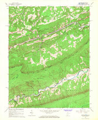
1965 Map of Oakvale
USGS Topo · Published 1966About this map
East River Mountain dominates the landscape of this mid-1960s survey, marking the rugged boundary between West Virginia and Virginia. Below the ridge, the Norfolk and Western railway corridor dictates the settlement pattern, connecting the communities of Oakvale, Kellysville, and Willowton along the East River. The map provides a detailed view of rural infrastructure during this era, including a High School and the Oakvale Fish Hatchery. Further south, the terrain transitions into the Jefferson National Forest, where the winding waters of Wolf Creek flow past remote outposts like Chapel and Boxley. For those researching local family history, several landmarks provide vital geographic anchors, from the Christian Ridge Ch and New Zion Ch in the north to the Beamer Cem nestled near the Virginia state line.
Find a feature on this map
58 named features on this map. Tap any name to fly to it.
Don’t see what you’re looking for? This feature index may not catch every label — zoom into the map to look around manually.
Map Details
Editions of this 1965 Oakvale Map
3 editions found
Other maps of this area

1887 · Pocahontas
USGS Topo · 1:125,000

1890 · Dublin
USGS Topo · 1:125,000

1891 · Pocahontas
USGS Topo · 1:125,000

1891 · Dublin
USGS Topo · 1:125,000

1894 · Pocahontas
USGS Topo · 1:125,000

1895 · Pocahontas
USGS Topo · 1:125,000

1913 · Peterstown
USGS Topo · 1:48,000

1913 · Bluefield
USGS Topo · 1:48,000

1916 · Bluefield
USGS Topo · 1:62,500

1916 · Peterstown
USGS Topo · 1:62,500