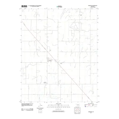
2010 Map of Oakwood
USGS Topo · Published 2010About this map
Oakwood serves as the primary hub in this section of Dewey County, where a grid of rural roads like E0750 Rd and N2410 Rd connects small farmsteads across the landscape. The layout reflects a deeply established agricultural community, anchored by historic social and burial sites. To the south of town lies the Independent Order of Odd Fellows Cemetery, a significant landmark for those tracing local fraternal history and genealogy, while the Oakwood Cemetery is situated just east of the main settlement. The terrain is marked by the path of Ninemile Creek, which flows through the eastern portion of the quadrangle. In the north, the small named locality of Leonel appears along the section lines, connected by a network of local routes including N2440 Rd.
Find a feature on this map
20 named features on this map. Tap any name to fly to it.
Don’t see what you’re looking for? This feature index may not catch every label — zoom into the map to look around manually.
Map Details
Editions of this 2010 Oakwood Map
This is the sole edition of this map. No revisions or reprints were ever made.
Other maps of this area

1955 · Clinton
USGS Topo · 1:250,000

1955 · Woodward
USGS Topo · 1:250,000

1957 · Clinton
USGS Topo · 1:250,000

1958 · Woodward
USGS Topo · 1:250,000

1962 · Putnam
USGS Topo · 1:62,500

1964 · Oakwood
USGS Topo · 1:62,500

1972 · Canton
USGS Topo · 1:24,000

1972 · Hucmac
USGS Topo · 1:24,000

1972 · Canton SW
USGS Topo · 1:24,000
1985 · Eagle City
USGS Topo · 1:24,000