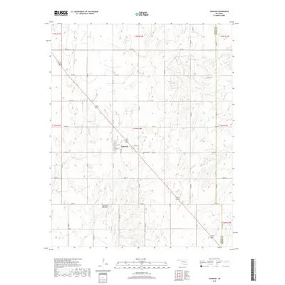
2018 Map of Oakwood
USGS Topo · Published 2018About this map
Oakwood sits at the heart of this Western Oklahoma landscape, where the township grid system organizes the rural Dewey County terrain. The settlement is defined by a traditional street plan featuring Main St, Walnut St, and regional avenues like Missouri Ave and Kansas Ave. This 2018 survey reveals the persistent character of a Great Plains community, where the local economy is tied to the surrounding section lines and agricultural allotments. Beyond the town center, the land is marked by significant cultural landmarks including the Independent Order of Odd Fellows Cem and the Oakwood Cem, which serve as vital touchstones for genealogical research. The hydrology of the area is dominated by the winding path of Ninemile Cr, which cuts through the eastern sections as it crosses the border between Dewey Co and Blaine Co.
Find a feature on this map
32 named features on this map. Tap any name to fly to it.
Don’t see what you’re looking for? This feature index may not catch every label — zoom into the map to look around manually.
Map Details
Editions of this 2018 Oakwood Map
This is the sole edition of this map. No revisions or reprints were ever made.
Other maps of this area

1955 · Clinton
USGS Topo · 1:250,000

1955 · Woodward
USGS Topo · 1:250,000

1957 · Clinton
USGS Topo · 1:250,000

1958 · Woodward
USGS Topo · 1:250,000

1962 · Putnam
USGS Topo · 1:62,500

1964 · Oakwood
USGS Topo · 1:62,500

1972 · Canton
USGS Topo · 1:24,000

1972 · Hucmac
USGS Topo · 1:24,000

1972 · Canton SW
USGS Topo · 1:24,000
1985 · Eagle City
USGS Topo · 1:24,000