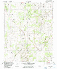
1985 Map of Oakwood
USGS Topo · Published 1985About this map
The town of Oakwood serves as the central hub of this mid-1980s survey, where the Atchison Topeka and Santa Fe railroad cuts a diagonal line across the landscape. The region is defined by its energy production, dominated by an extensive Oil and Gas Field that spans much of the northern half of the map. This industrial layer is set against a rural backdrop of rolling terrain and drainage systems like Ninemile Creek.
Find a feature on this map
15 named features on this map. Tap any name to fly to it.
Don’t see what you’re looking for? This feature index may not catch every label — zoom into the map to look around manually.
Map Details
Editions of this 1985 Oakwood Map
This is the sole edition of this map. No revisions or reprints were ever made.
Other maps of this area

1955 · Clinton
USGS Topo · 1:250,000

1955 · Woodward
USGS Topo · 1:250,000

1957 · Clinton
USGS Topo · 1:250,000

1958 · Woodward
USGS Topo · 1:250,000

1962 · Putnam
USGS Topo · 1:62,500

1964 · Oakwood
USGS Topo · 1:62,500

1972 · Canton
USGS Topo · 1:24,000

1972 · Hucmac
USGS Topo · 1:24,000

1972 · Canton SW
USGS Topo · 1:24,000
1985 · Eagle City
USGS Topo · 1:24,000