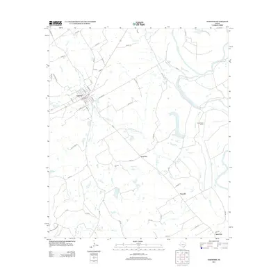
2013 Map of Oakwood
USGS Topo · Published 2013About this map
Oakwood serves as the primary hub in this eastern Texas landscape, situated along the RR 2 rail line and a network of local roads like N Main St and River Bend Rd. The terrain is defined by the winding course of the Trinity River along the eastern boundary, which has carved out numerous oxbow features including Glaze Lake, Criminal Lake, and McCrakin Lake. This hydrologic pattern suggests a low-lying, riparian environment subject to the river's historical shifts. Moving inland, the map identifies small rural communities and stopping points such as Sand Flats, Timesville, and Saint Paul. Local history is anchored by the Mt Pisgah Cem, while modern land use is represented by the Carter Ranch Airport and an extensive system of county roads and farm-to-market routes that connect the scattered settlements and agricultural tracts between Northwest Fork Boons Cr and Birch Cr.
Find a feature on this map
65 named features on this map. Tap any name to fly to it.
Don’t see what you’re looking for? This feature index may not catch every label — zoom into the map to look around manually.
Map Details
Editions of this 2013 Oakwood Map
This is the sole edition of this map. No revisions or reprints were ever made.
Other maps of this area

1951 · Elkhart
USGS Topo · 1:62,500

1953 · Palestine
USGS Topo · 1:250,000

1957 · Palestine
USGS Topo · 1:250,000

1964 · Long Lake
USGS Topo · 1:24,000

1964 · Oakwood
USGS Topo · 1:24,000

1964 · Flo
USGS Topo · 1:24,000

1964 · Keechi
USGS Topo · 1:24,000

1964 · Lake Leon
USGS Topo · 1:24,000
1964 · Butler
USGS Topo · 1:24,000

1964 · Stanmire Lake
USGS Topo · 1:24,000