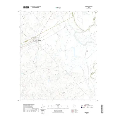
2019 Map of Oakwood
USGS Topo · Published 2019About this map
The town of Oakwood serves as the focal point for this study of the East Texas landscape, where the borders of Freestone, Anderson, and Leon Counties meet. Situated along a network of local roads such as Rocky Mount Rd and W Walston St, the settlement is defined by its grid of residential and commercial streets. The surrounding terrain is heavily influenced by the meandering Trinity River, which creates a complex hydrologic environment of oxbow lakes and creek systems. Notable water features include the strangely named Criminal Lake and McCracken Lake to the northeast, along with Lipsey Lake Number 2 near the town center.
Find a feature on this map
64 named features on this map. Tap any name to fly to it.
Don’t see what you’re looking for? This feature index may not catch every label — zoom into the map to look around manually.
Map Details
Editions of this 2019 Oakwood Map
This is the sole edition of this map. No revisions or reprints were ever made.
Other maps of this area

1951 · Elkhart
USGS Topo · 1:62,500

1953 · Palestine
USGS Topo · 1:250,000

1957 · Palestine
USGS Topo · 1:250,000

1964 · Long Lake
USGS Topo · 1:24,000

1964 · Oakwood
USGS Topo · 1:24,000

1964 · Flo
USGS Topo · 1:24,000

1964 · Keechi
USGS Topo · 1:24,000

1964 · Lake Leon
USGS Topo · 1:24,000
1964 · Butler
USGS Topo · 1:24,000

1964 · Stanmire Lake
USGS Topo · 1:24,000