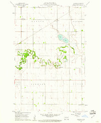
1960 Map of Oakwood
USGS Topo · Published 1961About this map
Park River meanders sharply across this Red River Valley landscape, creating a complex series of oxbows and bends including Horseshoe Coulee. This 1960 survey, published by the State of North Dakota Water Conservation Commission under Chairman Governor John E. Davis, captures the agrarian character of Walsh County during a period of established rail and air transport. The Northern Pacific railroad cuts a straight diagonal through the townships of Martin and St Andrews, serving the grain-handling point at Cashel.
Find a feature on this map
15 named features on this map. Tap any name to fly to it.
Don’t see what you’re looking for? This feature index may not catch every label — zoom into the map to look around manually.
Map Details
Editions of this 1960 Oakwood Map
This is the sole edition of this map. No revisions or reprints were ever made.
Other maps of this area

1918 · Acton
USGS Topo · 1:62,500

1939 · Drayton
USGS Topo · 1:62,500

1939 · Glasston
USGS Topo · 1:62,500

1941 · Drayton
USGS Topo · 1:62,500

1941 · Glasston
USGS Topo · 1:62,500

1943 · Grafton
USGS Topo · 1:62,500

1952 · Thief River Falls
USGS Topo · 1:250,000

1956 · Thief River Falls
USGS Topo · 1:250,000

1957 · Thief River Falls
USGS Topo · 1:250,000

1960 · Grafton
USGS Topo · 1:24,000