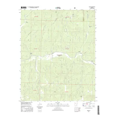
2017 Map of Oark
USGS Topo · Published 2017About this map
Oark and Catalpa serve as the primary human outposts within this section of the Ozark National Forest, situated along the winding course of the Mulberry River. The landscape is defined by its dramatic relief, where the river and its numerous tributaries, such as Panther Cr and Washita Cr, have carved out a complex system of hollows including Devil Jump Hollow and Acord Hollow. Transportation in this area is limited to a network of county roads like Oark Rd and footpaths, most notably the long-distance Ozark Highlands Trail which traverses the northern ridges. For those researching family history in Johnson County, the Miller Cem is a significant landmark, preserved on a high bench above the Little Mulberry Cr drainage. The proximity of Hignite Gap and McConnell Ridge further illustrates the challenging terrain that has historically shaped the settlement patterns and forestry operations of this Arkansas interior.
Find a feature on this map
48 named features on this map. Tap any name to fly to it.
Don’t see what you’re looking for? This feature index may not catch every label — zoom into the map to look around manually.
Map Details
Editions of this 2017 Oark Map
This is the sole edition of this map. No revisions or reprints were ever made.
Other maps of this area
1889 · Ozone
USGS Topo · 1:62,500
1906 · Batson
USGS Topo · 1:62,500
1934 · Ozone
USGS Topo · 1:62,500
1936 · Ozone
USGS Topo · 1:62,500
1956 · Russellville
USGS Topo · 1:250,000
1963 · Harmony
USGS Topo · 1:24,000
1963 · Hunt
USGS Topo · 1:24,000
1964 · Russellville
USGS Topo · 1:250,000
1967 · Fallsville
USGS Topo · 1:24,000
1973 · Boston
USGS Topo · 1:24,000