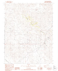
1987 Map of Oasis Divide
USGS Topo · Published 1987About this map
The Silver Peak Range dominates this landscape in Esmeralda County, revealing an arid expanse defined by high-altitude mining activity. The 1987 survey identifies several industrial sites, including the Heavy Rock Mine in the northern ridges and extensive Open Pit Mines further south. A significant historical marker, the Von Schmidt Line (1873), cuts across the southwestern corner, referencing the original 19th-century boundary survey between California and Nevada. High desert terrain is further marked by the geographic Oasis Divide, where transmission lines and unimproved roads navigate between peaks and through White Wolf Canyon. The map provides a clear record of the area's geological extraction and the persistence of early territorial boundaries.
Find a feature on this map
12 named features on this map. Tap any name to fly to it.
Don’t see what you’re looking for? This feature index may not catch every label — zoom into the map to look around manually.
Map Details
Editions of this 1987 Oasis Divide Map
This is the sole edition of this map. No revisions or reprints were ever made.
Other maps of this area

1898 · Silver Peak
USGS Topo · 1:125,000

1900 · Silver Peak
USGS Topo · 1:125,000

1908 · Lida
USGS Topo · 1:250,000

1913 · Lida
USGS Topo · 1:250,000

1954 · Goldfield
USGS Topo · 1:250,000

1955 · Goldfield
USGS Topo · 1:250,000

1957 · Magruder Mtn
USGS Topo · 1:62,500

1958 · Goldfield
USGS Topo · 1:250,000

1958 · Soldier Pass
USGS Topo · 1:62,500

1962 · Goldfield
USGS Topo · 1:250,000