
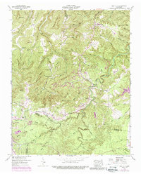
1946 Map of Obey City
USGS Topo · Published 1976About this map
The Cumberland Plateau terrain near the intersection of Overton, Putnam, and Cumberland counties defined a landscape of resource extraction and isolated ridge-top settlements during the mid-20th century. While the Tennessee Central Railroad corridor supported heavy industry, numerous strip mines began to mark the slopes around Obey City and Cliff Springs. This period shows the transition from traditional agriculture to intensive coal mining, though the cultural fabric remains tied to the land through family-named landmarks like Looper Cem, Thompson Cem, and Norrod Cem.
Find a feature on this map
94 named features on this map. Tap any name to fly to it.
Don’t see what you’re looking for? This feature index may not catch every label — zoom into the map to look around manually.
Map Details
Editions of this 1946 Obey City Map
2 editions found
Other maps of this area

1897 · Standingstone
USGS Topo · 1:125,000

1898 · Standingstone
USGS Topo · 1:125,000

1935 · Isoline
USGS Topo · 1:24,000

1935 · Campbell Junction
USGS Topo · 1:24,000

1935 · Clarkrange
USGS Topo · 1:24,000

1943 · Cookeville
USGS Topo · 1:100,000

1944 · Cookeville
USGS Topo · 1:100,000

1946 · Campbell Junction
USGS Topo · 1:24,000
1946 · Isoline
USGS Topo · 1:24,000

1946 · Clarkrange
USGS Topo · 1:24,000