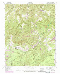
1946 Map of Obey City
USGS Topo · Published 1989About this map
The Obey City settlement and its surroundings on the Cumberland Plateau are defined by a complex landscape of narrow hollows and high ridges along the border of Overton County and Putnam County. This 1946 survey, later updated with aerial photography, reveals an economy and lifestyle shaped by rugged topography and resource extraction. Evidence of industrial activity is scattered throughout the drainages, including numerous strip mines and a notable Dismantled Railroad that once navigated the sharp relief of the hills.
Find a feature on this map
1 named feature on this map. Tap any name to fly to it.
Don’t see what you’re looking for? This feature index may not catch every label — zoom into the map to look around manually.
Map Details
Editions of this 1946 Obey City Map
2 editions found

Other maps of this area

1897 · Standingstone
USGS Topo · 1:125,000

1898 · Standingstone
USGS Topo · 1:125,000

1935 · Isoline
USGS Topo · 1:24,000

1935 · Campbell Junction
USGS Topo · 1:24,000

1935 · Clarkrange
USGS Topo · 1:24,000

1943 · Cookeville
USGS Topo · 1:100,000

1944 · Cookeville
USGS Topo · 1:100,000

1946 · Campbell Junction
USGS Topo · 1:24,000
1946 · Isoline
USGS Topo · 1:24,000

1946 · Clarkrange
USGS Topo · 1:24,000