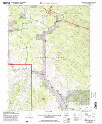
1994 Map of Observatory Rock
USGS Topo · Published 2001About this map
High-altitude ranching and timber legacies define this portion of the Pike National Forest in the mid-1990s. The landscape is marked by the transition from active livestock operations like Coleman Ranch and Highfill Ranch to the quiet remnants of early mountain industry, including the Arthur Sawmill (Site). The map preserves the location of the Bordenville (Site) settlement and the nearby Bordenville Cem, offering critical geographic data for researchers tracing the families who once occupied this reach of the Tarryall Creek valley.
Find a feature on this map
48 named features on this map. Tap any name to fly to it.
Don’t see what you’re looking for? This feature index may not catch every label — zoom into the map to look around manually.
Map Details
Editions of this 1994 Observatory Rock Map
This is the sole edition of this map. No revisions or reprints were ever made.
Other maps of this area

1937 · Como
USGS Topo · 1:62,500

1945 · Shawnee
USGS Topo · 1:24,000

1945 · Mount Logan
USGS Topo · 1:24,000

1948 · Mount Logan
USGS Topo · 1:24,000

1948 · Shawnee
USGS Topo · 1:24,000

1953 · Denver
USGS Topo · 1:250,000

1956 · Eagle Rock
USGS Topo · 1:24,000

1956 · Elkhorn
USGS Topo · 1:24,000

1956 · Farnum Peak
USGS Topo · 1:24,000

1957 · Denver
USGS Topo · 1:250,000