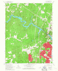
1966 Map of Occoquan
USGS Topo · Published 1968About this map
The Occoquan Reservoir and its surrounding woodland dominate this 1960s landscape, serving as a natural boundary between Fairfax and Prince William counties. To the south, the early footprint of Dale City begins to take shape, contrasting with established rural settlements like Hoadly and Minnieville. The eastern corridor is more densely developed, marked by the growth of Marumsco Village and Woodbridge along the Jefferson Davis Hwy.
Find a feature on this map
69 named features on this map. Tap any name to fly to it.
Don’t see what you’re looking for? This feature index may not catch every label — zoom into the map to look around manually.
Map Details
Editions of this 1966 Occoquan Map
4 editions found
Other maps of this area

1890 · Mt. Vernon
USGS Topo · 1:125,000

1891 · Mt. Vernon
USGS Topo · 1:125,000

1894 · Mt. Vernon
USGS Topo · 1:125,000

1897 · Mt. Vernon
USGS Topo · 1:125,000

1900 · Washington
USGS Topo · 1:62,500

1913 · Indian Head
USGS Topo · 1:62,500

1915 · Fairfax
USGS Topo · 1:62,500

1923 · Indian Head
USGS Topo · 1:48,000

1925 · Indian Head
USGS Topo · 1:62,500

1927 · Quantico
USGS Topo · 1:62,500