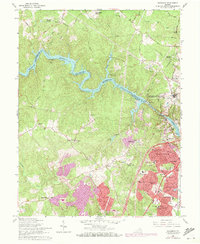
1966 Map of Occoquan
USGS Topo · Published 1971About this map
The Fairfax Co Prince William Co line follows the winding course of the Occoquan River, which is widened here by the Occoquan Dam to form the expansive Occoquan Reservoir. This 1966 survey, with 1971 purple-tinted updates, reveals the rapid suburbanization of Northern Virginia, particularly in the sprawling residential developments of Dale City and Marumsco Village. These growing neighborhoods contrast with the older, established core of Occoquan, where industrial features like Quarries and a Filtration Plant sit near the riverbank.
Find a feature on this map
79 named features on this map. Tap any name to fly to it.
Don’t see what you’re looking for? This feature index may not catch every label — zoom into the map to look around manually.
Map Details
Editions of this 1966 Occoquan Map
4 editions found
Other maps of this area

1890 · Mt. Vernon
USGS Topo · 1:125,000

1891 · Mt. Vernon
USGS Topo · 1:125,000

1894 · Mt. Vernon
USGS Topo · 1:125,000

1897 · Mt. Vernon
USGS Topo · 1:125,000

1900 · Washington
USGS Topo · 1:62,500

1913 · Indian Head
USGS Topo · 1:62,500

1915 · Fairfax
USGS Topo · 1:62,500

1923 · Indian Head
USGS Topo · 1:48,000

1925 · Indian Head
USGS Topo · 1:62,500

1927 · Quantico
USGS Topo · 1:62,500