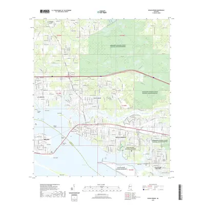
2020 Map of Ocean Springs
USGS Topo · Published 2020About this map
Biloxi and Ocean Springs dominate this coastal landscape at the junction of Back Bay of Biloxi and Biloxi Bay. The map illustrates a densely developed shoreline where the Memorial Bridge and Biloxi Bay Bridge link the two major cities across the water. Moving inland, the suburban residential patterns of St. Martin and Gulf Hills give way to extensive protected areas. Large sections of the Mississippi Sandhill Crane National Wildlife Refuge and the Gulf Islands National Seashore encompass the marshes and pine flatwoods, including Deer Island and Marsh Point. The northern reaches around Latimer show the branching drainage of Perigal Creek and Old Fort Bayou Creek, providing a clear view of the region's complex estuarine geography and contemporary infrastructure, such as the Ocean Springs Airport.
Find a feature on this map
45 named features on this map. Tap any name to fly to it.
Don’t see what you’re looking for? This feature index may not catch every label — zoom into the map to look around manually.
Map Details
Editions of this 2020 Ocean Springs Map
This is the sole edition of this map. No revisions or reprints were ever made.
Other maps of this area

1941 · Vancleave
USGS Topo · 1:62,500

1943 · Pascagoula
USGS Topo · 1:62,500

1943 · Vancleave
USGS Topo · 1:62,500

1944 · Vancleave
USGS Topo · 1:62,500

1953 · Mobile
USGS Topo · 1:250,000

1954 · Vestry
USGS Topo · 1:62,500

1954 · Ocean Springs
USGS Topo · 1:24,000

1954 · Biloxi
USGS Topo · 1:24,000

1954 · Deer Island
USGS Topo · 1:24,000

1954 · Biloxi
USGS Topo · 1:62,500
Featured Places
- Biloxi, MS
- Ocean Springs, MS
- Martins Pine Hill Estates, MS
- Saint Martin, MS
- Fort Bayou Estates, Ocean Springs