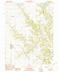
1982 Map of Oconee
USGS Topo · Published 1982About this map
Oconee and its surrounding countryside are defined by a network of rural cemeteries and creek bottoms along the Christian Co Shelby Co line. This early 1980s landscape retains a traditional settlement pattern, where small communities like Herrick and the southern edge of Pana are linked by the Illinois Central Gulf railroad. Local history and genealogy are centered on sites such as Sacred Heart Ch and its namesake Sacred Heart Cem, along with family and community grounds like Mount Cem and Oconee Mound Cem. The terrain is shaped by the drainage systems of Opossum Creek and Becks Creek, which feed into the northern reservoir of Lake Pana. The map provides a clear look at the area before modern developments significantly altered the rural Illinois character of these Shelby County townships.
Find a feature on this map
21 named features on this map. Tap any name to fly to it.
Don’t see what you’re looking for? This feature index may not catch every label — zoom into the map to look around manually.
Map Details
Editions of this 1982 Oconee Map
This is the sole edition of this map. No revisions or reprints were ever made.
Other maps of this area

1941 · St. Elmo
USGS Topo · 1:62,500

1942 · Shelbyville
USGS Topo · 1:62,500

1944 · Ramsey
USGS Topo · 1:62,500

1945 · St. Elmo
USGS Topo · 1:62,500

1946 · Shelbyville
USGS Topo · 1:62,500

1946 · Ramsey
USGS Topo · 1:62,500

1947 · Pana
USGS Topo · 1:62,500

1949 · Pana
USGS Topo · 1:62,500

1958 · Decatur
USGS Topo · 1:250,000

1961 · Decatur
USGS Topo · 1:250,000