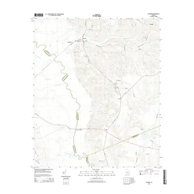
2014 Map of Oconee
USGS Topo · Published 2014About this map
The Oconee River carves a winding path along the western boundary of Washington County, defining the rural landscape of central Georgia as it appeared in the early 21st century. This region is characterized by its numerous small burial grounds and rural settlements, including Oconee and Gardner. The network of local roads such as Ohoopee Church Rd and Avant Cemetery Rd connects dispersed family and church-affiliated cemeteries like Antioch Cem and Bay Branch Cem. Historical industrial footprints are visible through labels like Kaolin Ln, reflecting the importance of kaolin mining in this geological belt. Water remains a central feature of the terrain, from Balls Ferry Bridge crossing Oochee Cr to the numerous smaller drainages like Little Sandy Hill Cr and Mikes Mill Cr that feed into the larger river system.
Find a feature on this map
64 named features on this map. Tap any name to fly to it.
Don’t see what you’re looking for? This feature index may not catch every label — zoom into the map to look around manually.
Map Details
Editions of this 2014 Oconee Map
This is the sole edition of this map. No revisions or reprints were ever made.
Other maps of this area

1916 · Irwinton
USGS Topo · 1:62,500

1920 · Irwinton
USGS Topo · 1:62,500

1957 · Macon
USGS Topo · 1:250,000

1958 · Macon
USGS Topo · 1:250,000

1962 · Oconee
USGS Topo · 1:24,000

1962 · Irwins Crossroads
USGS Topo · 1:24,000

1962 · Tabernacle
USGS Topo · 1:24,000

1962 · Sandersville
USGS Topo · 1:24,000

1964 · Macon
USGS Topo · 1:250,000
1973 · Toomsboro
USGS Topo · 1:24,000