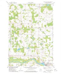
1974 Map of Oconto Falls North
USGS Topo · Published 1977About this map
The Oconto River winds through the southern landscape of this 1974 survey, anchoring a region defined by scattered dairy farms and small rural settlements like Spruce and Kelly Brook. To the south, the city of Oconto Falls begins to take shape, where the Chicago and North Western railroad line connects the community to wider industry. This map preserves a detailed look at the infrastructure of the mid-1970s, including an Old Railroad Grade and a network of named country roads such as Vatso Road and Valley Line Road that link the various townships.
Find a feature on this map
50 named features on this map. Tap any name to fly to it.
Don’t see what you’re looking for? This feature index may not catch every label — zoom into the map to look around manually.
Map Details
Editions of this 1974 Oconto Falls North Map
This is the sole edition of this map. No revisions or reprints were ever made.
Other maps of this area

1941 · Coleman
USGS Topo · 1:48,000

1942 · Coleman
USGS Topo · 1:48,000

1942 · Breed
USGS Topo · 1:48,000

1950 · Coleman
USGS Topo · 1:48,000

1952 · Mountain
USGS Topo · 1:48,000

1954 · Iron Mountain
USGS Topo · 1:250,000

1955 · Green Bay
USGS Topo · 1:250,000

1956 · Gillett
USGS Topo · 1:62,500

1956 · Oconto Falls
USGS Topo · 1:62,500

1959 · Iron Mountain
USGS Topo · 1:250,000