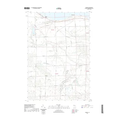
2019 Map of Ocqueoc
USGS Topo · Published 2019About this map
Ocqueoc River and its tributary, the Little Ocqueoc River, carve a significant path through this Northern Michigan landscape, culminating at the well-known Ocqueoc Falls. The river system defines the local geography, flowing north toward the settlement of Huron Beach on the Lake Huron shoreline. The map documents a predominantly rural township structure, with the small community of Ocqueoc situated inland. Genealogists will find several burial sites preserved here, including the Methodist Cem, Trinity Lutheran Cem, and the Ocqueoc Cem. These sites, along with the Ocqueoc Falls Bicentennial Pathway, indicate a landscape deeply tied to both early religious community life and modern outdoor recreation. A network of local routes like Cheboygan Plains Hwy and Glawe Hwy provides the primary infrastructure connecting the river valley to the coastal reaches near Hammond.
Find a feature on this map
66 named features on this map. Tap any name to fly to it.
Don’t see what you’re looking for? This feature index may not catch every label — zoom into the map to look around manually.
Map Details
Editions of this 2019 Ocqueoc Map
This is the sole edition of this map. No revisions or reprints were ever made.
Other maps of this area
1954 · Alpena
USGS Topo · 1:250,000
1955 · Cheboygan
USGS Topo · 1:250,000
1957 · Alpena
USGS Topo · 1:250,000
1957 · Onaway
USGS Topo · 1:62,500
1958 · Cheboygan
USGS Topo · 1:250,000
1958 · Alpena
USGS Topo · 1:250,000
1958 · Grace
USGS Topo · 1:62,500
1969 · Alpena
USGS Topo · 1:250,000
1971 · Hawks
USGS Topo · 1:24,000
1971 · Moltke
USGS Topo · 1:24,000