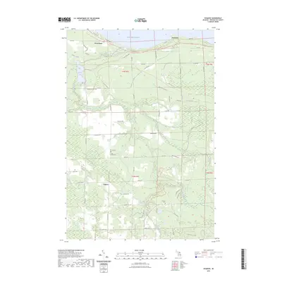
2023 Map of Ocqueoc
USGS Topo · Published 2023About this map
The Ocqueoc River and its various tributaries define this section of Presque Isle County near the shores of Lake Michigan. The settlement of Ocqueoc serves as a central point in a landscape marked by significant water features, including Ocqueoc Lake and the Ocqueoc Falls. For those researching local families, the map identifies three distinct burial sites: Methodist Cem, Trinity Lutheran Cem, and the Ocqueoc Cem further south. The coastline features the communities of Huron Beach and Hammond, connected by a network of local roads such as Acorn Ridge Hwy and Cheboygan Plains Hwy. The terrain is characterized by the winding paths of Silver Creek, Indian Creek, and the Little Ocqueoc River, which drain the lowlands before reaching the Great Lake.
Find a feature on this map
70 named features on this map. Tap any name to fly to it.
Don’t see what you’re looking for? This feature index may not catch every label — zoom into the map to look around manually.
Map Details
Editions of this 2023 Ocqueoc Map
This is the sole edition of this map. No revisions or reprints were ever made.
Other maps of this area

1954 · Alpena
USGS Topo · 1:250,000

1955 · Cheboygan
USGS Topo · 1:250,000

1957 · Alpena
USGS Topo · 1:250,000

1957 · Onaway
USGS Topo · 1:62,500

1958 · Cheboygan
USGS Topo · 1:250,000

1958 · Alpena
USGS Topo · 1:250,000

1958 · Grace
USGS Topo · 1:62,500

1969 · Alpena
USGS Topo · 1:250,000

1971 · Hawks
USGS Topo · 1:24,000
1971 · Moltke
USGS Topo · 1:24,000