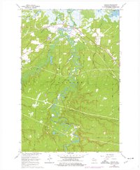
1964 Map of Odanah
USGS Topo · Published 1976About this map
The Bad River meanders through the wetlands and forests of northern Wisconsin in this mid-1960s study, reaching toward Lake Superior near the community of Odanah. The settlement is a focal point of activity, situated where the Chicago and North Western railroad crosses the river system. Local heritage is grounded in sites like the Odanah Ch and Odanah Cem, while the surrounding landscape is defined by the vast Hanson Swamp and numerous inland waters such as Alex Pond and Honest John Lake.
Find a feature on this map
26 named features on this map. Tap any name to fly to it.
Don’t see what you’re looking for? This feature index may not catch every label — zoom into the map to look around manually.
Map Details
Editions of this 1964 Odanah Map
2 editions found
Other maps of this area

1942 · Ashland
USGS Topo · 1:48,000

1942 · Mellen
USGS Topo · 1:48,000

1942 · Marengo
USGS Topo · 1:48,000

1943 · Odanah
USGS Topo · 1:48,000

1945 · Odanah
USGS Topo · 1:48,000

1945 · Marengo
USGS Topo · 1:48,000

1945 · Mellen
USGS Topo · 1:48,000

1947 · Ashland
USGS Topo · 1:48,000

1953 · Ashland
USGS Topo · 1:250,000

1958 · Ashland
USGS Topo · 1:250,000