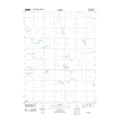
2011 Map of Odell
USGS Topo · Published 2011About this map
Big Indian Creek and its many tributaries carve a network of drainages across this southeastern Nebraska landscape, dominated by a sophisticated system of water management. The 2011 topography reveals an extensive series of reservoirs and dams, including Big Indian Creek Reservoir 6-E and Big Indian Creek Reservoir 5-A, designed to control the flow of local waterways. In the village of Odell, the community structure is anchored by the Odell Post Office and several significant burial grounds that reflect the area's heritage, such as the Czech National Cemetery and Saint Josephs Cemetery. Along the southern edge, Lanham sits directly on State Line Rd, marking the boundary between Gage County and the Kansas border. This survey provides a clear view of the rural road grid, from W Pine Rd in the north to the family-named Vitosh Reservoir and its associated dam in the southeast.
Find a feature on this map
53 named features on this map. Tap any name to fly to it.
Don’t see what you’re looking for? This feature index may not catch every label — zoom into the map to look around manually.
Map Details
Editions of this 2011 Odell Map
This is the sole edition of this map. No revisions or reprints were ever made.
Other maps of this area

1889 · Marysville
USGS Topo · 1:125,000

1894 · Marysville
USGS Topo · 1:125,000

1955 · Manhattan
USGS Topo · 1:250,000

1955 · Lincoln
USGS Topo · 1:250,000

1956 · Manhattan
USGS Topo · 1:250,000

1957 · Manhattan
USGS Topo · 1:250,000

1957 · Lincoln
USGS Topo · 1:250,000

1958 · Lincoln
USGS Topo · 1:250,000

1964 · Blue Springs
USGS Topo · 1:24,000
1966 · Herkimer
USGS Topo · 1:24,000